Map of North America
Map of North America > History | Travel Tips |
Relief Map | Topo Map
The United States is primarily an English-speaking country while Canada is officially English and French bilingual. Mexico and Central America are inhabited primarily by Spanish-speakers.
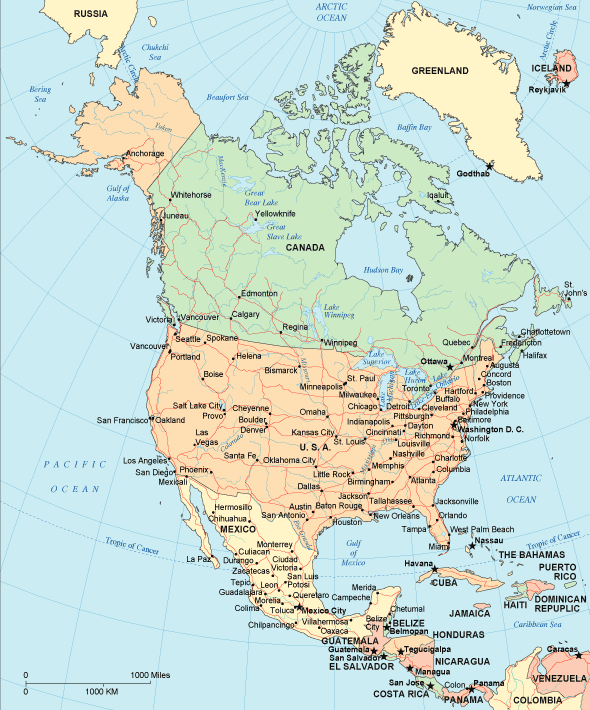 |
North America Map Navigation
To display the map in full-screen mode, click or touch the full screen button. To zoom in on the North America political map, click or touch the plus (+) button; to zoom out, click or touch the minus (-) button. To scroll or pan the zoomed-in map, either (1) use the scroll bars or (2) simply swipe or drag the map in any direction. (The scrolling or panning method you use will depend on your device and browser capabilities.) At any time, you can display the entire North America map in a new window or print this page, including the visible portion of the map.

North American Travel and Tourism > NA Travel Destinations
North America is the third largest continent and features the Coastal Range and Rocky Mountains running down the west coast from Alaska in the Arctic north to Central America in the Equatorial south. The continent also includes the fairly flat Canadian Shield, the Great Plains of the central interior, the Appalachian Mountains in eastern USA, and the coastal plain running from New Jersey down the Atlantic coast and along the Gulf of Mexico. Three of its five Great Lakes are among the five largest lakes in the world.The largest city in North America is Mexico City; other leading cities include New York, Los Angeles, Chicago, Philadelphia, and Toronto. North America is served by an extensive network of international and domestic airlines as well as a well-maintained highway network. The Pan American Highway was designed to provide road access between North and South America, but this highway has not yet been completed through southeastern Panama. The unfinished portion of the road is known as the Darien Gap. Good online sources of North American news include CNN, The New York Times, and BBC's US and Canada News.
North America History and Antique North America Map
This North America history page provides an overview of North American history and culture from ancient times to modern times. This vintage map of North America shows the continent of North America as it appeared in a 19th century atlas.Related Continent Map Sites
- Map Of Asia - Asian maps.
- Map Of Europe - European maps.
- Map Of South America - South American maps.
All rights reserved. About us.
Certain maps hereon are © Map Resources.